Bio
Contact
Professional Photography/Video Services - Punta Gorda, Florida
Industrial/Commercial-Architecture-Composites-Portraits-Scenics-Nature-Pano Photo-Video-Photo Techniques-Site Map


Quick Scouting New Locations: I recently responded to a Forum where someone was visiting the Florida Gulf coast and they where interested for some ideas where to shoot. So it occurred to me that many people may not know about Google Earth or the new features it offers. For those who never heard of Google Earth it is a free interactive I often will zoom into an area first just to see the satellite map of an area's feature. This gives me clues to what I might be able to shoot. But now there are these icons that look as a white circle with a blue stroke and star in the center. Click on that and see views others have shot. It's a great way to scoop out an unknown location. Of course these views are not very often professional images but it is a great resource. Not only can you see some local images but the Google Map is clear enough and it's easy to determine the direction of the sun. OK sure this is not the only way to map an unknown area for shooting images but another tool for the gear bag! |
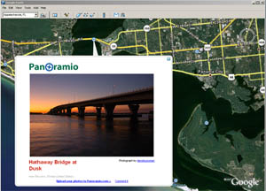 |
| * Snap shop of Google Earth with an enlargement from Panoramio icon |
All material within this website is copyright © 2006